SIOS-InfraNor is the first major investment in research infrastructure coordinated by SIOS-KC.
See SIOS-InfraNor in Research in Svalbard portal
The Research Council of Norway (RCN) allocates funding for advanced scientific equipment, large-scale research facilities, scientific databases and collections, and electronic infrastructure through its National Financing Initiative for Research Infrastructure (INFRASTRUKTUR). In 2016 SIOS-KC coordinated an application to RCN, "SIOS – Infrastructure development of the Norwegian node (SIOS-InfraNor)". The Svalbard component of the Climate-ecological Observatory for Arctic Tundra (COAT) was later integrated into SIOS-InfraNor.
The total funding for the combined project is 94.27 million NOK. In addition the Norwegian Space Agency (NoSA) has agreed to finance the project with a further 13 million NOK earmarked for space related activities.
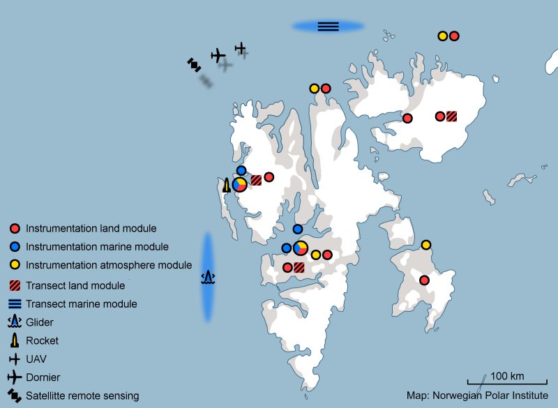
SIOS-InfraNor will fund a diverse range of items, from new instruments to remote sensing products. The infrastructure funded through SIOS-InfraNor will be integrated into the observational network of SIOS and will benefit the entire SIOS community. Data resulting from the project will be made available on the SIOS data portal. Some of the infrastructure is already available to researchers via the SIOS Access Programme (see Call 2018). Although the focus of SIOS is on interdisciplinary research, SIOS-InfraNor has been divided into thematic topics for the purposes of project management.
- Module 1: Atmosphere, Leader: Dr W Aas (NILU)
-
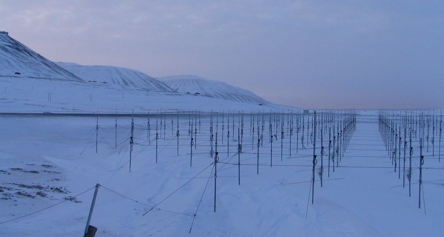
SOUSY antennae. Photo: Chris Hall The new atmospheric infrastructure addresses issues closely linked to the land and ocean modules regarding meteorology, climate, surface energy/radiation processes and their impact on Arctic ecosystems, as well as trace gas and aerosol characteristics and transport. In addition, there is a strong need to better understand the coupling between space and the upper and lower atmosphere. This coupling is most pronounced in the polar cap region, and Svalbard is at a particularly well-suited location for efforts to strengthen understanding.
The atmospheric module is organised in three thematic sections: meteorological/climate observatory stations, vertical coupling processes in the atmosphere from ground to space, and radiation and energy budget in the Arctic troposphere.
Table 1: Items that are part of the atmosphere module of SIOS-InfraNor. *indicates item is funded by NoSA, all other items are funded by RCN and in-kind contributions from project partners.
ID#
Description
Owner
1
Upgrade of three AWS (Verlegenhuken, Karl XII Land, Edgeøya)
MET
4
ICI Hotel Payload: 2 × 4D Space sections (for 12 daughter modules), ready to plug in instruments, payload services
UiO
5
Rocket campaign from Ny-Ålesund in January 2019
UiO
6
Two-stage motors configured for the ICI-5 projects
UiO
7
Upgrading of ground-based instrumentation for middle and upper atmosphere observations (MST SOUSY radar)
UiT
8*
Upgrade of Ionosonde antenna
UiT
11
Aerodynamic particle sizer
NILU
12
PFR lunar photometer
NILU
14*
Pandora spectrometer
NILU
- Module 2: Land, Leader: Dr ÅØ Pedersen (NPI)
-
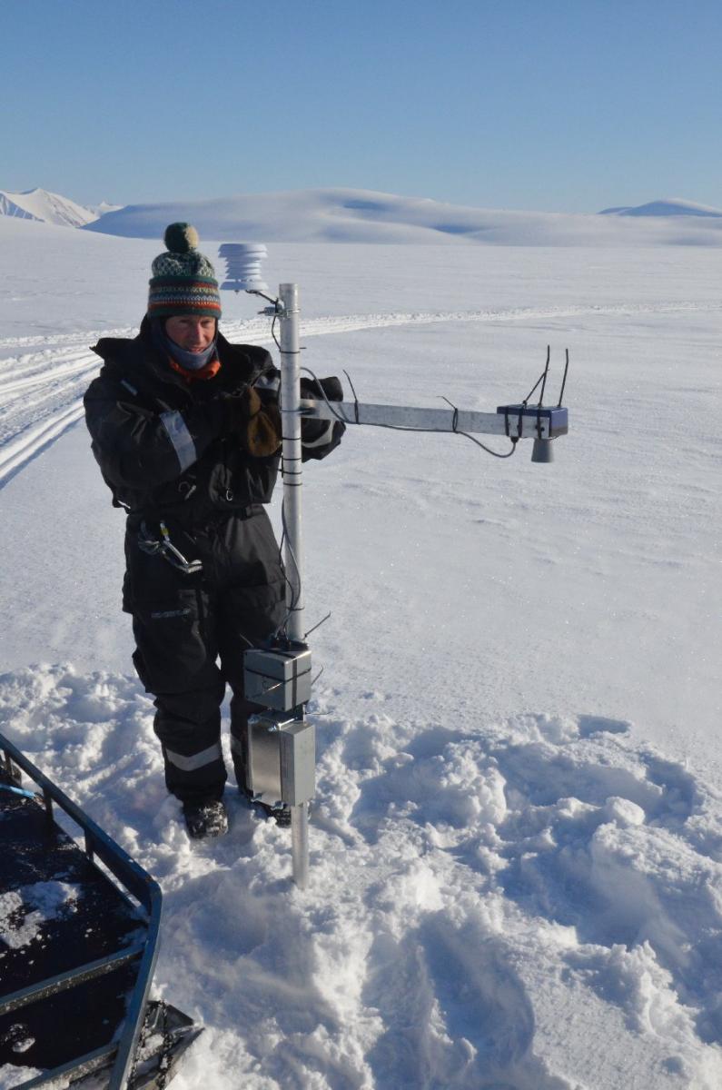
Automatic weather station. Photo: JC Gallet The land module establishes a joint Arctic Terrestrial Observatory that combines the following key scientific topics: glaciology, snow, hydrology, permafrost and biosphere. Much of the infrastructures will be tied to the two SIOS super-site regions of Kongsfjorden and Isfjorden. Additional instrumentation will be placed in eastern Svalbard for glaciology, snow and permafrost, consisting of autonomous borehole thermistors, snow sensors and weather stations. This will ensure detailed data for coupled process modelling at the local scale, as well as a basic observational coverage of the west-east climatic gradient in Svalbard for larger scale studies and Earth System models.
Existing monitoring programmes for glaciology, hydrology and permafrost will be expanded and strengthened to provide time series of various climatic parameters rather than just averaged results within the respective disciplines. Permafrost data will go into the NORPERM database, and weather data from glaciology and hydrology will be homogenised with those in the atmospheric module to be useful for meteorological model validation and forecasting. Snow monitoring will be established in Kongsfjorden, Isfjorden and at Austfonna, and will extend the climate observation network of COAT, which includes both field data sampling and snow modelling. The COAT snow monitoring and modelling will be supplemented with additional remote sensing and calibration-validation. Remote sensing will also be used to extend ground observations of snow parameters and the biosphere to the rest of Svalbard.
Table 2: Items that are part of the terrestrial module of SIOS-InfraNor. *indicates item is funded by NoSA, all other items are funded by RCN and in-kind contributions from project partners.
ID#
Description
Owner
68-69
Glacier monitoring in Kongsfjorden and at Austfonna: AWS
NPI, UiO
35
Snow monitoring transects in Kongsfjorden and at Austfonna: ground penetrating radar, snow properties and accumulation/temperature sensors
NPI, UNIS, UiO
37
Hydrology monitoring in Kongsfjorden and Isfjorden: 2 new and 2 upgraded stations, including AWS
NVE
31, 41
Permafrost monitoring of new and upgraded boreholes in west/east Svalbard, including an expanded drill rig and one deeper hole in Adventdalen (150 m)
UNIS, MET
42-43
Remote sensing of snow parameters and avalanche activity, including calibration/validation with in situ data
Norut
44-45*, 49, 51-53*
Establishment of an Automatic System for Monitoring and mapping Vegetation and Environmental seasonal changes on Svalbard
UiT, Norut, NINA
70-73
Ecosystem observation network, including optical and acoustic sensors, telemetry and herbivore exclosures
NPI, MET
75-76
Climate observatory network, including AWS and snow pack measuring instruments
NPI, MET
77
Design, implementation and operationalisation of original COAT tasks
NPI
- Module 3: Ocean, Leader: Professor J Berge (UiT)
-
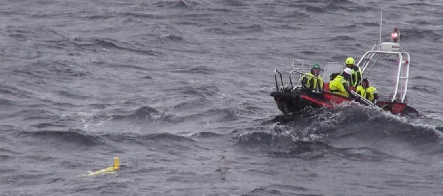
Glider. Photo: UiB The ocean module contains a combination of new Arctic Ocean observatories replacing existing outdated infrastructure, and extending existing observatories that have a proven track record of suitability for long term monitoring. It also includes an autonomous platforms, a seaglider, which will supplement long-term observatories with short-term and high-resolution spatial coverage of target sites. The integration of stationary fixed observatories with mobile autonomous vehicles will provide unique insights into the biological and physical factors influencing and characterising the dynamics of the marine environment around Svalbard.
Observatories will offer the capabilities needed to address the following key topics:
Physical and biological oceanographic coupling; Energy of ocean currents; Ocean nutrients and pollutants (horizontally, vertically and through the food chain); and Ecosystem resilience to climate seasonal variability and long-term change.
SIOS-InfraNor will concentrate on four main mooring arrays (main responsible institutions in brackets): Arctic Ocean inflow along the slope north of Svalbard (IMR and NPI), shelf regions along the north and west coast of Svalbard (UiT and UNIS) and Arctic Ocean governance of greenhouse gas release monitored by a world class ocean-observatory Kongsberg system for both the shallow and deep Arctic region offshore north Svalbard (CAGE/UiT). In addition, the infrastructure includes gliders for oceanographic surveys in and outside the fjords (UiB). The proposed infrastructure serves long-term time series for monitoring and research (infrastructure designed to be deployed on a continuous basis) and process-oriented studies (infrastructure subject to funding and collaboration with research projects/priorities).
Table 3: Items that are part of the ocean module of SIOS-InfraNor. All items are funded by RCN and in-kind contributions from project partners.
ID#
Description
Owner
58
Mooring array north of Svalbard to measure Arctic Ocean inflow, sensors of physical, biochemical and biological relevance. Combined with #59
NPI
59
Mooring array north of Svalbard to measure Arctic Ocean inflow, sensors of physical, biochemical and biological relevance. Combined with #58
IMR
60
Oceanographic glider to operate in the fjords and off-shelf west of Svalbard
UiB
61
K-lander to measure methane and other greenhouse gas exchange from the sea floor to the sea surface
UiT
62
Oceanographic mooring in Kongsfjorden for physical, biochemical and biological time series studies
UiT
63
Oceanographic mooring in Isfjorden for physical, biochemical and biological time series studies
UNIS
64
Oceanographic mooring in Adventfjorden for physical, biochemical and biological time series studies
NIVA
- Module 4: Common infrastructure, Leader: Associate Professor R Storvold (NORUT)
-
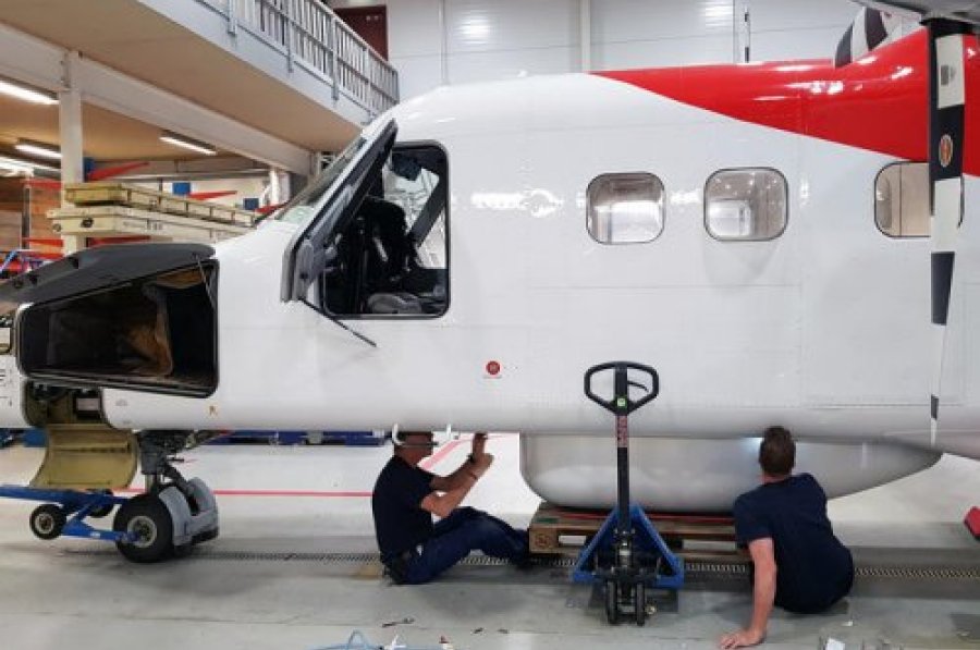
Instruments on Dornier. Photo: Rannveig H. Stiberg In this module, new interdisciplinary research infrastructure is introduced, which will contribute unique data collection capacities of new data time series and process studies supporting the cross-disciplinary priorities of SIOS. The fact that the infrastructure and sensor capacities have multiple applications leads to the creation of the Common Infrastructure Module.
The module contains one manned aircraft platform and one unmanned platform. The sensor suite mounted on the manned platform has already been installed in a pod permanently affixed to the Lufttransport Dornier DO228 aircraft based in Longyearbyen. The instrumentation includes a hyperspectral imager, X-band synthetic aperture radar and a high-resolution high sensitivity camera. The Dornier platform has a range of 2000 km which is covered in about 5-6 hours. The unmanned platform consists of two medium size multirotor drones, using a proven off the shelf system that has a very small operational footprint making it easy to deploy them in remote field locations or on ships. The multirotor drones are equipped with a range of cameras and will be used for terrestrial ecology studies, animal population and behaviour studies, land forms and hydrology studies.
In support of the SIOS observatories for monitoring Arctic ocean inflow and outflow, the Nansen Environmental and Remote Sensing Center (NERSC) will develop and set up the production of time series of satellite remote sensing ocean products based on satellite SAR data from Radarsat-2 and Sentinel-1. This includes high-resolution wind, ocean surface currents, altimetry, gravimetry, and high-resolution sea ice drift and sea-ice types. From optical satellite data from Modis and Sentinel-2, weekly high resolution chlorophyll concentration maps will be created. Provided sufficient resolution, some of these datasets may also be applicable to the shelf region observatories in Kongsfjorden and Isfjorden. The in situ data obtained in other parts of the project will thus also serve as a valuable validation source for the remote sensing algorithms.
Table 4: Items that are part of the common infrastructure module of SIOS-InfraNor. *indicates item is funded by NoSA, all other items are funded by RCN and in-kind contributions from project partners.
ID#
Description
Owner
18
Instruments to be installed in Dornier DO228 POD, airborne SAR, VNIR hyperspectral Imager, vis/NIR aerial camera and laser scanner.
Norut
23*
Satellite SAR wind retrieval to produce daily maps of wind speed and direction, and monthly surface current maps
NERSC
27*
Satellite based high resolution chlorophyll concentration, weekly maps
NERSC
78
Two medium size multirotor drones with NDVI, RGB and thermal cameras
Norut
- Module 5: Data management, Leader: Dr Ø Godøy (SIOS)
-
The SIOS Data Policy promotes free and open access to data. It is a requirement that scientists and projects utilising the SIOS Infrastructure also adhere to the SIOS Data Policy and deposit data in a data centre contributing to the SIOS Data Management System (SDMS).
The main focus of SIOS-InfraNor data management is to ensure that the data generated by the proposed instrumentation are properly taken care of and shared through SDMS. SDMS is a physically distributed data management system. As such, data must be managed by a number of data centres contributing to SIOS. To ensure a functional system, SIOS relies on internationally approved standards for documentation of and access to data. Utilisation of standards allows integration with discipline-specific (e.g. WMO Information System) and regional (e.g. Copernicus Marine Environmental Monitoring Service) data management systems. Development of the SDMS technical infrastructure is aligned with current efforts of e.g. the combined SAON/IASC Data Committee and builds on the experience of distributed data management during the International Polar Year.
SIOS-InfraNor data management activities are primarily focused on documentation and encoding of datasets, and submission of these to data centres committed to life cycle management of data (including long-term data preservation). This allows integration of SIOS-InfraNor data streams into the SDMS. In this process SIOS-InfraNor relies on existing national infrastructures and data centres and their present business models. Costs related to data documentation and encoding as well as long-term data preservation and publishing of data are included in the data management module. The central search interface and data access point of SDMS are already covered by SIOS.
- Module 6: Management, Leader: Dr H Lihavainen (SIOS)
-
The management module focuses on coordinating the construction and testing of the infrastructure owned by the partners and thematically organised in modules 1-4. The project management also has the task of ensuring that the SIOS-InfraNor project is fully utilising the SIOS-KC services and that the SIOS-InfraNor funded items are integrated into SIOS as a whole.
The management module is led by the project leader (SIOS Director), and the six module leaders (Modules 1-6) together form the project leader group.
The following SIOS member institutions are partners in SIOS-InfraNor:
- Geological Survey of Norway
- Institute of Marine Research
- Nansen Environmental and Remote Sensing Center
- Norut Northern Research Institute
- Norwegian Institute for Air Research
- Norwegian Institute for Nature Research
- Norwegian Institute for Water Research
- Norwegian Meteorological Institute
- Norwegian Water Resources and Energy Directorate
- The Norwegian Polar Institute
- The University Centre in Svalbard
- UiT The Arctic University of Norway
- University of Bergen
- University of Oslo