The research infrastructure investment project "SIOS – Infrastructure development of the Norwegian node (SIOS-InfraNor)", which kicked off in 2018, has gained momentum over the course of this year. A number of items have already been deployed or are undergoing testing as we speak. For the items already gathering data, work is underway to make them available on the SIOS Data Portal. This article contains short descriptions of some of the infrastructure deployed in 2019.
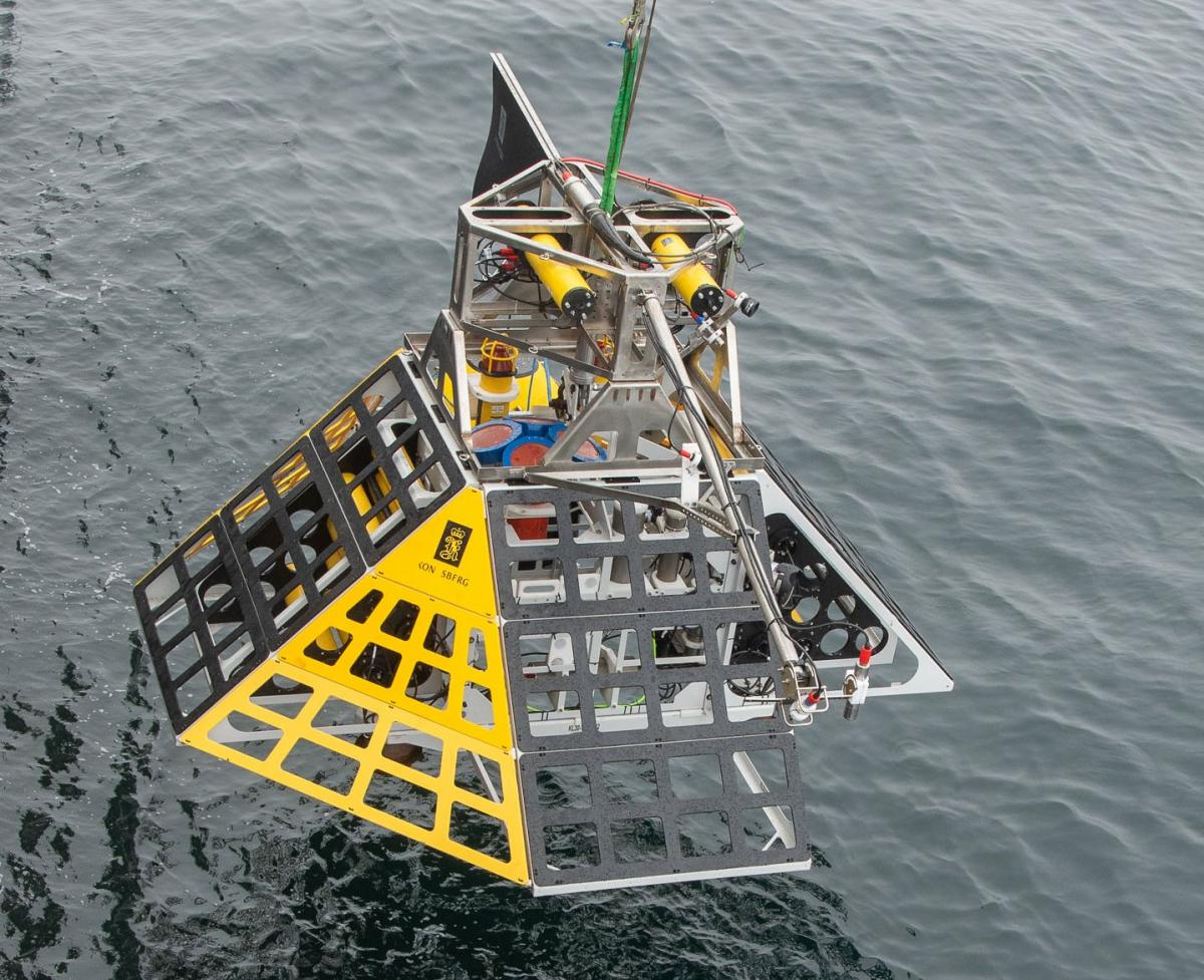
K-lander (lead institution: UiT The Arctic University of Norway)
SIOS-Infranor funded the re-deployment of the K-lander in 2019, sent on the sea floor offshore Prins Karls Foreland for the 3rd time since 2016. The K-lander comes from a cooperation between the Centre of Excellence CAGE (Centre for Arctic Gas Hydrate, Environment and Climate) hosted by UiT and Kongsberg Maritime. This lander, located on an intense methane seepage area, will monitor for a full year the variability of methane seepage as well as the causal effect of the surrounding ocean parameters.
Hyperspectral imager installed on Dornier aircraft (lead institution: NORCE)
NORCE has instrumented a Dornier aircraft, operated by Lufttransport, with high-resolution sensors and advanced communication equipment for environmental monitoring. The aircraft flies regular passenger flights from Longyearbyen to Svea and Ny-Ålesund, and may also be chartered for custom flights. The first test flights were conducted at the end of August 2019, and SIOS members were invited to send in requests of areas to fly over while testing the optical equipment. Many SIOS members took advantage of this opportunity, and project manager Agnar Sivertsen is eager to receive feedback from them on the imagery once analysis is complete.
You can read more on the NORCE web page: https://www.norceresearch.no/en/insight/verdens-forste-passasjerfly-for-miljoovervaking-er-norsk
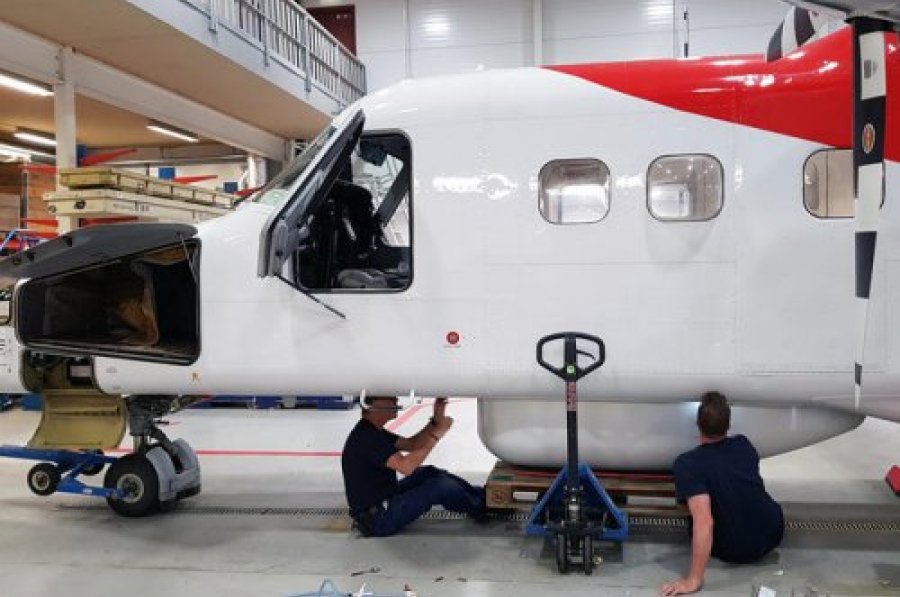
(Photo: Rannveig H. Stiberg).
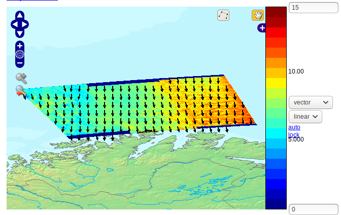
Sentinel-1 SAR wind fields (lead institution: Nansen Environmental and Remote Sensing Center)
Daily CMOD5 (for neutral winds) processing of high resolution Sentinel-1 SAR wind fields has recently been set up at the Nansen Center. The wind fields are estimated from VV polarized medium resolution (40 m) SAR normalized radar cross section (NRCS) combined with wind directions from the AROME-Arctic forecast model, available from the Norwegian ground segment and the Norwegian Meteorological Institute. The wind fields are made available to SIOS via the OPeNDAP protocol on the thredds server at the Nansen Center and will soon be ingested in the SIOS data catalogue.
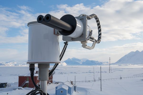
Pandora instrument (lead institution: Norwegian Institute for Air Research)
The NILU Pandora was installed at the Sverdrup Station in Ny-Ålesund 14th September 2019. With a location of almost 79N and 12E the instrument is the northernmost instrument in the world of its kind, and provides an excellent opportunity to monitor and access data from clean background air masses. Data from the Pandora instrument will be used by ESA and others as Fiducial Reference Measurements (FRM) for Sentinel-5P. FRMs provide the maximum Return On Investment (ROI) for a satellite mission by delivering, to users, the required confidence in data products, in the form of independent validation results and satellite measurement uncertainty estimation, over the entire end-to-end duration of a satellite mission.
The planned data products are:
- Total and tropospheric ozone (O3) column
- Total and tropospheric nitrogen dioxide (NO2) column
- Spectral aerosol optical depth (AOD) in the ultraviolet (>300nm) and visible range
- The possibility of adding other data products such as sulfur dioxide (SO2), formaldehyde (CH2O), and water vapor (H2O) columns might also be explored
Pandonia is a ground-based remote sensing network of Pandora instruments. At NILU we are very proud of being able to bring Norway into to this network (and of course with valuable contribution from SIOS and Norsk Romsenter) and to contribute to this work in the future.
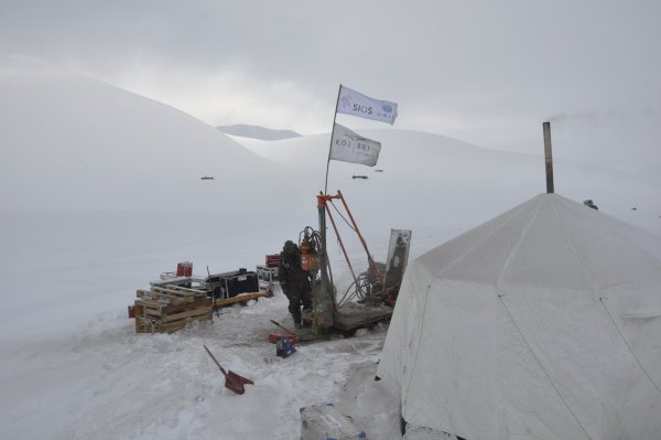
Permafrost boreholes (lead institutions: University Centre in Svalbard and Norwegian Meteorological Institute)
There has been a great deal of drilling activity for permafrost boreholes for SIOS-InfraNor, conducted by Kolibri Geo Services on behalf of UNIS and MET Norway. From March to May 2019, during 45 field days, Kolibri Geo Services driller Ullrich Neumann and drill assistant Hans-Henning Heyn drilled 167m of borehole in seven different landforms primarily in the Adventdalen area. The average depth of the boreholes is 21m. Permafrost cores were retrieved from 64 of the metres drilled. New thermistor strings that record the ground temperature regime were installed during late summer in all the new boreholes.
The drilling team also established the northernmost permafrost monitoring borehole in Svalbard, at Verlegenhuken in August 2019. After a full year of preparation, finally permafrost temperatures can be monitored at 80°N!
COAT infrastructure (lead institutions: Norwegian Polar Institute, Norwegian Meteorological Institute, UiT The Arctic University of Norway)
The Climate Ecological Observatory for Arctic Tundra (COAT) is an observation system that enable long-term, real-time detection, documentation, understanding and predictions of climate impacts on arctic tundra ecosystems. The Svalbard-section of COAT is at the core of the SIOS-InfraNor land module and is currently implementing research infrastructure for the long-term monitoring effort. COAT Svalbard has now implemented and operationalised several types of research infrastructure in the core areas in Nordenskiöld Land and in Brøgger Peninsula. These include:
- automatic full-scale weather stations in inland sites in Adventdalen and Reindalen;
- GPS transmitters on arctic fox and reindeer to track behavioural responses to the changing environmental conditions;
- sound stations to passively record ptarmigan abundance;
- automatic camera monitoring of arctic fox dens, breeding geese and vegetation phenology;
- vegetation monitoring stations in moss tundra and dryas habitats important to herbivores;
- drone photography to quantify small scale patch and habitat changes from herbivore activity;
- ground surface temperature loggers to detect onset of seasons and icing event;
- snow models at ecological relevant temporal and spatial scales, and;
- cabins for field personnel.
Dryas vegetation (Photo: Jakob Assmann, NPI)
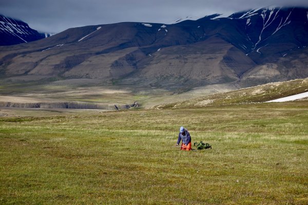
Automated vegetation monitoring (lead institutions: Norwegian Institute for Nature Research, UiT The Arctic University of Norway)
These instruments are designed as automatic systems for sampling ground truth information on vegetation growth season phenology for validation and calibration of satellite earth observation data. One instrument array records incoming and reflected radiation (visible and near-infrared – NDVI and photochemical reflectance index - PRI), surface temperature sensor, soil moisture and temperature at ground plots within ten common plant communities distributed in Adventdalen. Ordinary RGB cameras are also mounted on the racks taking daily pictures of vegetation.
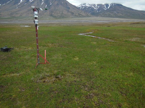
soil moisture and temperature sensor, and red-green-blue wavelength (RGB) camera (Photo: Lennart Nilsen).
Another instrument is the newly developed FLoX field spectrometer designed for high-resolution spectral measurements of radiances and for Sun-Induced Fluorescence (SIF) retrieval. SIF represents a direct proxy for photosynthesis and ecosystem carbon-flux, hence a new global proxy for gross primary production. The instrument was set up within the footprint of an already established Eddy-Covariance - carbon-flux tower, and will also act as calibration point for instrument #44.
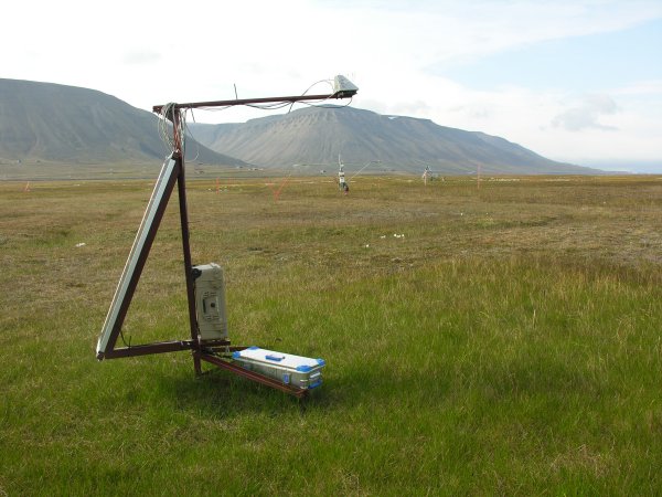
near and within the footprint of the Eddy-Covariance station in Adventdalen - which can be seen on the photo. (Photo: Lennart Nilsen).
