Kongsfjorden Rijpfjorden Observatory Programme (KROP) - Rijpfjorden Observatory Contact Full Name Daniel Vogedes email daniel.vogedes@uit.no Institution UiT The Arctic University of Norway Info Observation Facility Landing Page https://www.mare-incognitum.no/krop/ Observation Facility Type sea platform (fixed) Observation Facility Status Operational Core data Yes Observation Facility ID RiS ID(s) 11106 11107 Geospatial location Coordinates POINT (22.299317 80.295563) Height above mean sea level (m) -20.00 Environment Site Information Observatory moored with anchor weight. Bottom depth around 220 m. About 200 m of mooring line. Subsurface buoyancy at about 20 m water depth (hence the -20 m above sea level which refers to the start of the mooring line, not an actual instrument depth). Top 20 m left empty due to risk of ice scouring. Main "photo" is an example of a mooring diagram from 2021. Mooring setup is similar for other years, but does have changes in the details. Additional photos to illustrate some of the instrumentation. Data is available at https://archive.sigma2.no/ split up according to years and sensor types. Observed Variable(s) Observed Variable OCEANS>OCEAN TEMPERATURE>WATER TEMPERATURE Start Date 2006-09-01T12:00:00Z Instrument model and serial number Various instruments since 2006. Mostly SeaBird SBE16/19p, SBE56, SBE37. During the first years Vemco microloggers were used instead of SBE56. Instrument routine maintenance Instrument turnaround once a year. In most years, instruments will be sent to SeaBird for calibration. Often intercalibration with shipboard CTD. Sampling procedures Sampling intervals vary between 12 minutes (SBE56) and 4 hours (SBE16/19p). Observed Variable OCEANS>SALINITY/DENSITY>CONDUCTIVITY Start Date 2006-09-01T12:00:00Z Instrument model and serial number Various SeaBird SBE16/19p and SBE37 Instrument routine maintenance Instrument turnaround once a year. In most years, instruments will be sent to SeaBird for calibration. Often intercalibration with shipboard CTD. Sampling procedures Sampling interval between 2-4 hours year round Observed Variable OCEANS>SALINITY/DENSITY>SALINITY Start Date 2006-09-01T12:00:00Z Instrument model and serial number Various SeaBird SBE16/19p and SBE37 Instrument routine maintenance Instrument turnaround once a year. In most years, instruments will be sent to SeaBird for calibration. Often intercalibration with shipboard CTD. Sampling procedures Sampling interval between 2-4 hours year round. Derived variable from conductivity, temperature and depth. Observed Variable OCEANS>OCEAN OPTICS>FLUORESCENCE Start Date 2006-09-01T12:00:00Z Instrument model and serial number Various fluorescence sensors (Wetlabs and Seapoint) Instrument routine maintenance Annual check with fluorescence stick, occasional factory service. Sampling procedures Sampling interval 4 hours. Data published as raw voltage readings, as proper chlorophyll a fluorescence values would require regular water sampling for chl a calibration. Main point is to detect phytoplankton bloom timing, not absolute chl a values. Observed Variable OCEANS>OCEAN OPTICS>TURBIDITY Start Date 2006-09-01T12:00:00Z Instrument model and serial number Seapoint turbidity sensor Instrument routine maintenance Occasional calibration Sampling procedures Sampling interval 4 hours. Only deployed a few years. Observed Variable OCEANS>OCEAN ACOUSTICS>AMBIENT NOISE Start Date 2013-09-01T12:00:00Z Instrument model and serial number Multi-Electronique AURAL M2/M3 various s/n Instrument routine maintenance No specific maintenance Sampling procedures Hydrophone recording varied over the years. Mostly 10 min recording / hour but several years with power issues and incomplete recordings Observed Variable OCEANS>OCEAN ACOUSTICS>ACOUSTIC SCATTERING Start Date 2006-09-01T12:00:00Z Instrument model and serial number RDI Workhorse 300 kHz ADCP various s/n Instrument routine maintenance no specific maintenance, annual battery replacement and data recovery Sampling procedures Deployed at 100 m, one upward and one downward facing. 20 min ensemble interval, 1 min ping interval, 20 pings / ensemble, 30 depth cells, 4 m depth cell size Observed Variable OCEANS>MARINE SEDIMENTS>SEDIMENTATION Start Date 2006-09-01T12:00:00Z Instrument model and serial number McLane Mark 78H-21 Sediment trap 21-way on non-regular schedule (higher rate during peak sedimentation time). Instrument routine maintenance No specific maintenance, annual recovery, service and redeployment. Sampling procedures 500 ml bottles. Samples on 4% Formalin (mostly buffered with Borax, occasionally Hexamin, since 2023: no buffer) Standard sampling schedule: 1 16/09/2022 2 01/10/2022 3 01/11/2022 4 01/12/2022 5 01/01/2023 6 01/02/2023 7 01/03/2023 8 15/03/2023 9 29/03/2023 10 12/04/2023 11 26/04/2023 12 10/05/2023 13 24/05/2023 14 07/06/2023 15 21/06/2023 16 28/06/2023 17 05/07/2023 18 12/07/2023 19 19/07/2023 20 26/07/2023 21 09/08/2023 22 23/08/2023 (open) Additional photos Read more about Kongsfjorden Rijpfjorden Observatory Programme (KROP) - Rijpfjorden Observatory
Riometer (40MHz) Contact Full Name Chris Hall/Magnar Gullikstad email chris.hall@uit.no Institution UiT The Arctic University of Norway Info Observatory Sverdrup Observation Facility Type land platform (fixed) Observation Facility Status Operational Core data No Observation Facility ID RiS ID(s) 6696 Geospatial location Coordinates POINT (11.93007 78.92346) Height above mean sea level (m) 10.00 Observed Variable(s) Observed Variable SUN-EARTH INTERACTIONS>IONOSPHERE/MAGNETOSPHERE DYNAMICS>GEOMAGNETIC INDICES Start Date 1966-01-01T12:00:00Z Sampling procedures Continuous Read more about Riometer (40MHz)
Riometer (30MHz) Contact Full Name Chris Hall/Magnar Gullikstad email chris.hall@uit.no Institution UiT The Arctic University of Norway Info Observatory Sverdrup Observation Facility Type land platform (fixed) Observation Facility Status Operational Core data No Observation Facility ID RiS ID(s) 6696 Geospatial location Coordinates POINT (11.93007 78.92346) Height above mean sea level (m) 10.00 Observed Variable(s) Observed Variable SUN-EARTH INTERACTIONS>IONOSPHERE/MAGNETOSPHERE DYNAMICS>GEOMAGNETIC INDICES Start Date 1966-01-01T12:00:00Z Sampling procedures Continuous Read more about Riometer (30MHz)
Magnetometer Contact Full Name Magnar Gullikstad Johnsen email Magnar.G.Johnsen@uit.no Institution UiT The Arctic University of Norway Info Observation Facility Type land platform (fixed) Observation Facility Status Operational Core data No Observation Facility ID RiS ID(s) 6083 Geospatial location Coordinates POINT (11.934090986939 78.922565165179) Height above mean sea level (m) 11.00 Environment Site Information TGO web-pages (http://flux.phys.uit.no/geomag.html); IMAGE network (space.fmi.fi/image/beta/); SuperMAG (http://supermag.uib.no/); World Data Centers for geomagnetism (http://www.wdc.bgs.ac.uk/ Observed Variable(s) Observed Variable SOLID EARTH>GEOMAGNETISM>MAGNETIC FIELD Start Date 1966-01-01T12:00:00Z Landing Page http://flux.phys.uit.no/geomag.html Read more about Magnetometer
Kongsfjorden Rijpfjorden Observatory Programme (KROP) - Kongsfjorden Observatory Contact Full Name Daniel Vogedes email daniel.vogedes@uit.no Institution UiT The Arctic University of Norway Info Observation Facility Landing Page https://www.mare-incognitum.no/krop/ Observation Facility Type sea platform (fixed) Observation Facility Status Operational Core data Yes Part of SIOS Project InfraNOR Observation Facility ID RiS ID(s) 11107 11106 Geospatial location Coordinates POINT (11.82048 78.959905) Height above mean sea level (m) -20.00 Environment Site Information Observatory moored with anchor weight. Bottom depth around 220 m. About 200 m of mooring line. Subsurface buoyancy at about 20 m water depth (hence the -20 m above sea level which refers to the start of the mooring line, not an actual instrument depth). Top 20 m left empty due to risk of ice scouring. Main "photo" is an example of a mooring diagram. Mooring setup is similar for other years, but does have changes in the details. Additional photos to illustrate some of the instrumentation. Data is available at https://archive.sigma2.no/ split up according to years and sensor types. Observed Variable(s) Observed Variable OCEANS>SALINITY/DENSITY>CONDUCTIVITY Start Date 2006-06-06T12:00:00Z Instrument model and serial number Various SeaBird SBE16/19p and SBE37 Instrument routine maintenance Instrument turnaround once a year. In most years, instruments will be sent to SeaBird for calibration. Often intercalibration with shipboard CTD. Sampling procedures Sampling intervals vary between 12 minutes (SBE56) and 4 hours (SBE16/19p). Observed Variable OCEANS>OCEAN TEMPERATURE>WATER TEMPERATURE Start Date 2006-06-06T12:00:00Z Instrument model and serial number Various instruments since 2006. Mostly SeaBird SBE16/19p, SBE56, SBE37. During the first years Vemco microloggers were used instead of SBE56. Instrument routine maintenance Instrument turnaround once a year. In most years, instruments will be sent to SeaBird for calibration. Often intercalibration with shipboard CTD. Sampling procedures Sampling intervals vary between 12 minutes (SBE56) and 4 hours (SBE16/19p). Observed Variable OCEANS>MARINE SEDIMENTS>SEDIMENTATION Start Date 2006-06-06T12:00:00Z Instrument model and serial number McLane Mark 78H-21 Sediment trap 21-way on non-regular schedule (higher rate during peak sedimentation time). Instrument routine maintenance No specific maintenance, annual recovery, service and redeployment. Sampling procedures 500 ml bottles. Samples on 4% Formalin (mostly buffered with Borax, occasionally Hexamin, since 2023: no buffer) Standard sampling schedule: 1 16/09/2022 2 01/10/2022 3 01/11/2022 4 01/12/2022 5 01/01/2023 6 01/02/2023 7 01/03/2023 8 15/03/2023 9 29/03/2023 10 12/04/2023 11 26/04/2023 12 10/05/2023 13 24/05/2023 14 07/06/2023 15 21/06/2023 16 28/06/2023 17 05/07/2023 18 12/07/2023 19 19/07/2023 20 26/07/2023 21 09/08/2023 22 23/08/2023 (open) Observed Variable OCEANS>OCEAN ACOUSTICS>ACOUSTIC SCATTERING Start Date 2006-06-06T12:00:00Z Instrument model and serial number RDI Workhorse 300 kHz ADCP various s/n Instrument routine maintenance no specific maintenance, annual battery replacement and data recovery Sampling procedures Deployed at 100 m, one upward and one downward facing. 20 min ensemble interval, 1 min ping interval, 20 pings / ensemble, 30 depth cells, 4 m depth cell size Observed Variable OCEANS>SALINITY/DENSITY>SALINITY Start Date 2006-06-06T12:00:00Z Instrument model and serial number Various SeaBird SBE16/19p and SBE37 Instrument routine maintenance Instrument turnaround once a year. In most years, instruments will be sent to SeaBird for calibration. Often intercalibration with shipboard CTD. Sampling procedures Sampling interval between 2-4 hours year round. Derived variable from conductivity, temperature and depth. Observed Variable OCEANS>OCEAN ACOUSTICS>AMBIENT NOISE Start Date 2013-09-01T12:00:00Z Instrument model and serial number Multi-Electronique AURAL M2/M3 various s/n Instrument routine maintenance No specific maintenance Sampling procedures Hydrophone recording varied over the years. Mostly 10 min recording / hour but several years with power issues and incomplete recordings Observed Variable OCEANS>OCEAN OPTICS>TURBIDITY Start Date 2006-09-01T12:00:00Z Instrument model and serial number Seapoint turbidity sensor Instrument routine maintenance Occasional calibration Sampling procedures Sampling interval 4 hours. Only deployed a few years. Additional photos Read more about Kongsfjorden Rijpfjorden Observatory Programme (KROP) - Kongsfjorden Observatory
Ionosonde Ny-Ålesund Contact Full Name Chris Hall; Magnar Gullikstad Johnsen email chris.hall@uit.no; magnar.g.johnsen@uit.no Institution UiT The Arctic University of Norway Info Observation Facility Type land platform (fixed) Observation Facility Status Planned Core data Yes Part of SIOS Project InfraNOR Observation Facility ID RiS ID(s) 11222 Geospatial location Coordinates POINT (11.89 78.92) Height above mean sea level (m) 50.00 Environment Site Information Transmit and receive antennas located immediately NW of "Gruvebadet". Radar hardware indoors in "Gruvebadet" Observed Variable(s) Observed Variable SUN-EARTH INTERACTIONS>IONOSPHERE/MAGNETOSPHERE DYNAMICS>ION CHEMISTRY/IONIZATION Start Date 2020-09-01T12:00:00Z Landing Page http://radars.uit.no/ionosondeNAL/METADATA_IONOSONDE_NAL.txt Instrument model and serial number CADI ionosonde Instrument routine maintenance best effort Sampling procedures typically ionograms every 15 minutes, but programmable. Height and frequency resolution - contact PI Observed Variable SUN-EARTH INTERACTIONS>IONOSPHERE/MAGNETOSPHERE DYNAMICS>ELECTRIC FIELDS/ELECTRIC CURRENTS Start Date 2020-09-01T12:00:00Z Landing Page http://radars.uit.no/ionosondeNAL/METADATA_IONOSONDE_NAL.txt Instrument model and serial number CADI ionosonde Instrument routine maintenance best effort Sampling procedures typically ionograms every 15 minutes, but programmable. Height and frequency resolution - contact PI Read more about Ionosonde Ny-Ålesund
K-Lander - UiT/CAGE Contact Full Name Benedicte Ferre email benedicte.ferre@uit.no Institution UiT The Arctic University of Norway Info Observation Facility Type underwater platform (fixed) Observation Facility Status Operational Core data Yes Part of SIOS Project InfraNOR Geospatial location Coordinates POINT (10.13414 78.56366) Height above mean sea level (m) -90.00 Observed Variable(s) Observed Variable OCEANS>OCEAN TEMPERATURE>WATER TEMPERATURE Start Date 2019-07-15T12:00:00Z Observed Variable OCEANS>SALINITY/DENSITY>SALINITY Start Date 2019-07-15T12:00:00Z Observed Variable OCEANS>OCEAN CIRCULATION>OCEAN CURRENTS Start Date 2019-07-15T12:00:00Z Observed Variable OCEANS>OCEAN ACOUSTICS>AMBIENT NOISE Start Date 2019-07-15T12:00:00Z Observed Variable OCEANS>OCEAN CHEMISTRY>MARINE GEOCHEMISTRY Start Date 2019-07-15T12:00:00Z Observed Variable OCEANS>OCEAN ACOUSTICS>ACOUSTIC SCATTERING Start Date 2019-07-15T12:00:00Z Observed Variable OCEANS>OCEAN CHEMISTRY>CARBON DIOXIDE Start Date 2019-07-15T12:00:00Z Observed Variable OCEANS>OCEAN CHEMISTRY>DISSOLVED GASES Start Date 2019-07-15T12:00:00Z Read more about K-Lander - UiT/CAGE
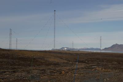
Adventdalen Field Station Contact Full Name Chris Hall email chris.hall@uit.no Institution UiT The Arctic University of Norway Info Observation Facility Type land platform (fixed) Observation Facility Status Operational Core data Yes Part of SIOS Project InfraNOR Observation Facility ID RiS ID(s) 3729 Geospatial location Coordinates POINT (15.99172 78.16985) Height above mean sea level (m) 39.00 Observed Variable(s) Observed Variable ATMOSPHERE>CLOUDS>MESOSPHERIC CLOUDS (OBSERVED/ANALYZED)>POLAR MESOSPHERIC CLOUDS Start Date 2019-05-01T12:00:00Z Landing Page http://radars.uit.no/sousy6/METADATA_DECODED.txt http://radars.uit.no/sousy6/METADATA_MESOSPHERE.txt Instrument model and serial number ATRAD MST radar Instrument routine maintenance When required Sampling procedures normally 10 min Observed Variable ATMOSPHERE>ATMOSPHERIC WINDS>WIND DYNAMICS>TURBULENCE Start Date 2019-05-01T12:00:00Z Landing Page http://radars.uit.no/sousy6/METADATA_DECODED.txt Instrument model and serial number ATRAD MST radar Instrument routine maintenance when required Sampling procedures Normally 10 min Observed Variable ATMOSPHERE>ATMOSPHERIC WINDS>WIND DYNAMICS>HORIZONTAL WIND VELOCITY/SPEED Start Date 2019-05-01T12:00:00Z Landing Page http://radars.uit.no/sousy6/METADATA_DECODED.txt Instrument model and serial number ATRAD meteor wind radar Instrument routine maintenance when requuired Sampling procedures nominally 2 minutes, but to generate results 1 hour data collection before dissemination Observed Variable ATMOSPHERE>ALTITUDE>TROPOPAUSE Start Date 2020-01-01T12:00:00Z Landing Page http://radars.uit.no/sousy6/METADATA_TROPOSPHERE.txt Instrument model and serial number ATRAD MST radar Instrument routine maintenance when required Sampling procedures Normally 10 min Observed Variable SPECTRAL/ENGINEERING>RADAR>RADAR BACKSCATTER Start Date 2019-05-01T12:00:00Z Landing Page http://radars.uit.no/sousy6/METADATA_DECODED.txt Instrument model and serial number ATRAD MST radar Instrument routine maintenance when required Sampling procedures Nominally 10 min, summary plots daily Additional photos Read more about Adventdalen Field Station
")
")

 antennas to left, meteor radar to right")
