Maria Curie-Skłodowska University in Lublin

Weather Station UMCS-1 - CALYPSOBYEN

Contact
Piotr Zagórski
piotr.zagorski@mail.umcs.pl
Info
land platform (fixed)
Partly operational
Observation Facility ID
11672
12193
11620
11363
10165
6784
4981
1169
951
3918
5762
Geospatial location
POINT (14.5135 77.5583)
19.00
Environment
Meteorological observations have been carried out since 1986 during summer Polar Expedition organized by Maria Curie-Sklodowska University. Until 1998, these observations were conducted using analog methods, which included the use of mercury thermometers inside instrument shelters. Since 1999, automatic weather stations (AWS) have been employed. Depending on the type of station, various meteorological parameters were recorded. In general, the following variables were monitored: air temperature at 2 meters above ground, humidity, atmospheric pressure, wind speed and direction, precipitation, solar radiation, and ground temperature (at ground level).
AWS units were installed either on meteorological masts or on aluminum tripods.

2022-2023 - AWS is installed on an aluminum tripod.
The temperature sensors are positioned at a height of approximately 2 meters above the land surface.

Project “Autonomous quasi-distributed optical fiber temperature sensor for ground temperature measurements” (SPILOD), as part of the Smart Growth Operational Programme 2014-2020 3/4.1.1/2019 Joined Venture named “Lublin Upland of Photonic Technologies” implemented by the National Centre for Research and Development.
Project period: 01.01.2021 - 31.12.2023 (2029)
Observed Variable(s)
ATMOSPHERE>ATMOSPHERIC TEMPERATURE>SURFACE TEMPERATURE>AIR TEMPERATURE
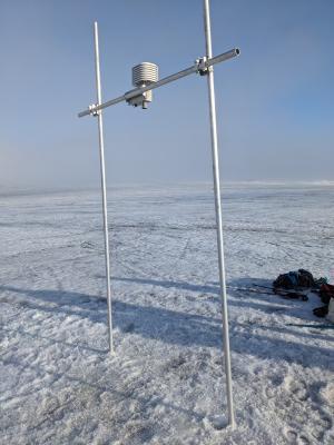
Since the beginning of the observations, a variety of measuring instruments and electronic devices have been employed:
- from 1986 to 1996 and in 1998: instrument shelter with mercury thermometers.
- from 1999 to 2002, 2005 to 2016, and in 2021-2023: automatic weather stations (AWS), with different types used during these periods.

HDMCS-100 – Meteo Compact was used during the summer seasons of 2022 and 2023.
https://www.deltaohm.com/product/hdmcs-100-all-in-one-meteo-compact-station/
Maintenance and operation of the weather station occur exclusively during the summer months as part of the Maria Curie-Sklodowska Polar Expeditions, specifically in June, July, and August.
AWS - Sampling every 10 min and saving to internal memory.
ATMOSPHERE>ATMOSPHERIC PRESSURE>ATMOSPHERIC PRESSURE MEASUREMENTS
ATMOSPHERE>ATMOSPHERIC WINDS>SURFACE WINDS
ATMOSPHERE>ATMOSPHERIC RADIATION>SOLAR RADIATION
ATMOSPHERE>PRECIPITATION>PRECIPITATION RATE
ATMOSPHERE>ATMOSPHERIC WATER VAPOR>WATER VAPOR INDICATORS>HUMIDITY>RELATIVE HUMIDITY
Additional photos

Automatic Weather Station CRIOS-1 - CALYPSOBYEN

Contact
Piotr Zagórski
piotr.zagorski@mail.umcs.pl
Info
land platform (fixed)
Operational
Yes
Observation Facility ID
12089
Geospatial location
POINT (14.50955 77.56147)
4.00
Environment
AWS is installed on the cabin approximately 400 meters NNW from Calypsobyen Station. The lens is aimed at us SE.
The height of sensors is approximately 2 m above land surface.

CRIOS – Cryosphere Integrated Observation Network on Svalbard
Project financed from the EEA Financial Mechanism 2014-2021 operated by the National Science Centre in Poland
Agreement no. UMO-2022/43/7/ST10/00001 to a predefined project no. 2022/43/7/ST10/00001
Project period: 08.09.2022 - 30.04.2024 (2029)
Observed Variable(s)
ATMOSPHERE>ATMOSPHERIC TEMPERATURE>SURFACE TEMPERATURE>AIR TEMPERATURE
https://www.onsetcomp.com/products/sensors/s-thc-m002
Maintenance takes place at least once a year in spring (March/April) or summer (July/August).
Sampling every 1 hour and saving to internal SD card.
Data transmission via the Iridium system every 72 hours.
ATMOSPHERE>ATMOSPHERIC WATER VAPOR>WATER VAPOR INDICATORS>HUMIDITY>RELATIVE HUMIDITY
https://www.onsetcomp.com/products/sensors/s-thc-m002
Maintenance takes place at least once a year in spring (March/April) or summer (July/August).
Sampling every 1 hour and saving to internal SD card.
Data transmission via the Iridium system every 72 hours.
ATMOSPHERE>ATMOSPHERIC WINDS>SURFACE WINDS>WIND SPEED
https://www.onsetcomp.com/products/sensors/s-wcf-m003
Maintenance takes place at least once a year in spring (March/April) or summer (July/August).
Sampling every 1 hour and saving to internal SD card.
Data transmission via the Iridium system every 72 hours.
ATMOSPHERE>ATMOSPHERIC WINDS>SURFACE WINDS>WIND DIRECTION
https://www.onsetcomp.com/products/sensors/s-wcf-m003
Maintenance takes place at least once a year in spring (March/April) or summer (July/August).
Sampling every 1 hour and saving to internal SD card.
Data transmission via the Iridium system every 72 hours.
ATMOSPHERE>ATMOSPHERIC RADIATION>INCOMING SOLAR RADIATION
https://www.onsetcomp.com/products/sensors/s-lib-m003
Maintenance takes place at least once a year in spring (March/April) or summer (July/August).
Sampling every 1 hour and saving to internal SD card.
Data transmission via the Iridium system every 72 hours.
Additional photos

Timelaps camera - CALYPSOBYEN

Contact
Piotr Zagórski
piotr.zagorski@mail.umcs.pl
Info
land platform (fixed)
Operational
Yes
Observation Facility ID
12089
Geospatial location
POINT (14.50966 77.56148)
4.00
Environment
Timelaps camera is installed on the cabin approximately 400 meters NNW from Calypsobyen Station. The lens is aimed at us SE.

CRIOS – Cryosphere Integrated Observation Network on Svalbard
Project financed from the EEA Financial Mechanism 2014-2021 operated by the National Science Centre in Poland
Agreement no. UMO-2022/43/7/ST10/00001 to a predefined project no. 2022/43/7/ST10/00001
Project period: 08.09.2022 - 30.04.2024 (2029)
Observed Variable(s)
CRYOSPHERE>SNOW/ICE>SNOW COVER
https://seesense.eu/shop/camdo-time-lapse-solution-bundles/
- Sony DSC-RXO II camera system
- SolarUp Bundle Comprising
- CamDo 9 Watt Solar panel upgrade kit for Dry X enclosure
- SanDisk Extreme Plus micro SD Card SDXC 128GB 170MB/s

A time-lapse camera takes photos of the snow cover and ground cover in the area of the station in Calypsobyen.
Maintenance takes place at least once a year in spring (March/April) or summer (July/August).
Sampling every 6 hours and saving to internal SD card.
LAND SURFACE>LANDSCAPE>LANDSCAPE PROCESSES
https://seesense.eu/shop/camdo-time-lapse-solution-bundles/
- Sony DSC-RXO II camera system
- SolarUp Bundle Comprising
- CamDo 9 Watt Solar panel upgrade kit for Dry X enclosure
- SanDisk Extreme Plus micro SD Card SDXC 128GB 170MB/s

A time-lapse camera takes photos of the snow cover and ground cover in the area of the station in Calypsobyen.
Maintenance takes place at least once a year in spring (March/April) or summer (July/August).
Sampling every 6 hours and saving to internal SD card.

SPICE: Autonomous snow depth and glacier ablation station - RENARDBREEN_2

Contact
Piotr Zagórski
piotr.zagorski@mail.umcs.pl
Info
land platform (on ice)
Operational
Yes
Observation Facility ID
12089
Geospatial location
POINT (14.31578 77.49227)
416.00
Environment
https://a2photonicsensors.com/spice-snow-depth-real-time/
Spice - IoT telemetric sensor for snowpack depth measurement.
The Spice sensor is a sonar-based sensor used for measuring the depth of the snowpack and monitoring its evolution during the winter season. The instrument performs temperature compensation so as to increase the accuracy of the measurement.

CRIOS – Cryosphere Integrated Observation Network on Svalbard
Project financed from the EEA Financial Mechanism 2014-2021 operated by the National Science Centre in Poland
Agreement no. UMO-2022/43/7/ST10/00001 to a predefined project no. 2022/43/7/ST10/00001
Project period: 08.09.2022 - 30.04.2024 (2029)

Second contact person: Michał Laska (michal.laska@us.edu.pl)
Observed Variable(s)
CRYOSPHERE>SNOW/ICE>SNOW DEPTH
The sensor is installed on two poles on the glacier. Service and lowering of the sensor are planned at least once a year in spring (March/April) or summer (July/August).
Sampling every 1 hour and saving to internal SD card.
LAND SURFACE>GEOMORPHIC LANDFORMS/PROCESSES>GLACIAL PROCESSES>ABLATION
The sensor is installed on two poles on the glacier. Service and lowering of the sensor are planned at least once a year in spring (March/April) or summer (July/August).
Sampling every 1 hour and saving to internal SD card.
ATMOSPHERE>ATMOSPHERIC TEMPERATURE>SURFACE TEMPERATURE>AIR TEMPERATURE
The sensor is installed on two poles on the glacier. Service and lowering of the sensor are planned at least once a year in spring (March/April) or summer (July/August).
Sampling every 1 hour and saving to internal SD card.
• Range: -40/+65 °C
• Accuracy: ± 0.8 °C
• Resolution: 0.1 °C

SPICE: Autonomous snow depth and glacier ablation station - RENARDBREEN_1

Contact
Piotr Zagórski
piotr.zagorski@mail.umcs.pl
Info
land platform (on ice)
Operational
Yes
Observation Facility ID
12089
Geospatial location
POINT (14.39992 77.51715)
242.00
Environment
https://a2photonicsensors.com/spice-snow-depth-real-time/
Spice - IoT telemetric sensor for snowpack depth measurement.
The Spice sensor is a sonar-based sensor used for measuring the depth of the snowpack and monitoring its evolution during the winter season. The instrument performs temperature compensation so as to increase the accuracy of the measurement.

CRIOS – Cryosphere Integrated Observation Network on Svalbard
Project financed from the EEA Financial Mechanism 2014-2021 operated by the National Science Centre in Poland
Agreement no. UMO-2022/43/7/ST10/00001 to a predefined project no. 2022/43/7/ST10/00001
Project period: 08.09.2022 - 30.04.2024 (2029)

Second contact person: Michał Laska (michal.laska@us.edu.pl)

Observed Variable(s)
CRYOSPHERE>SNOW/ICE>SNOW DEPTH
The sensor is installed on two poles on the glacier. Service and lowering of the sensor are planned at least once a year in spring (March/April) or summer (July/August).
Sampling and recording every 1 hour, data transmission via the Iridium system every 48 hours.
The sensor is installed approx. 2 m above snow-free glacier surface.
LAND SURFACE>GEOMORPHIC LANDFORMS/PROCESSES>GLACIAL PROCESSES>ABLATION
The sensor is installed on two poles on the glacier. Service and lowering of the sensor are planned at least once a year in spring (March/April) or summer (July/August).
Sampling and recording every 1 hour, data transmission via the Iridium system every 48 hours.
The sensor is installed approx. 2 m above snow-free glacier surface.
ATMOSPHERE>ATMOSPHERIC TEMPERATURE>SURFACE TEMPERATURE>AIR TEMPERATURE
The sensor is installed on two poles on the glacier. Service and lowering of the sensor are planned at least once a year in spring (March/April) or summer (July/August).
Sampling and recording every 1 hour, data transmission via the Iridium system every 48 hours.
The sensor is installed approx. 2 m above snow-free glacier surface.
• Range: -40/+65 °C
• Accuracy: ± 0.8 °C
• Resolution: 0.1 °C
Additional photos

SPICE: Autonomous snow depth station - CALYPSOBYEN

Contact
Piotr Zagórski
piotr.zagorski@mail.umcs.pl
Info
land platform (fixed)
Operational
Yes
Observation Facility ID
12089
Geospatial location
POINT (14.50467 77.5611)
26.00
Environment
SPICE
https://a2photonicsensors.com/spice-snow-depth-real-time/
Spice - IoT telemetric sensor for snowpack depth measurement.
The Spice sensor is a sonar-based sensor used for measuring the depth of the snowpack and monitoring its evolution during the winter season. The instrument performs temperature compensation so as to increase the accuracy of the measurement.

CRIOS – Cryosphere Integrated Observation Network on Svalbard
Project financed from the EEA Financial Mechanism 2014-2021 operated by the National Science Centre in Poland
Agreement no. UMO-2022/43/7/ST10/00001 to a predefined project no. 2022/43/7/ST10/00001
Project period: 08.09.2022 - 30.04.2024 (2029)

Second contact person: Michał Laska (michal.laska@us.edu.pl)
Observed Variable(s)
CRYOSPHERE>SNOW/ICE>SNOW DEPTH
The sensor is serviced once a year in July-August when data is collected.
Snow depth is measured with the ultrasonic sensor every 60 minutes and recorded on the internal SD card.
The sensor is installed approx. 1.5 m above snow-free land surface.
ATMOSPHERE>ATMOSPHERIC TEMPERATURE>SURFACE TEMPERATURE>AIR TEMPERATURE
The sensor is serviced once a year in July-August when data is collected.
Air temperature is measured every 60 minutes and recorded on the internal SD card.
The sensor is installed approx. 1.5 m above snow-free land surface.
• Range: -40/+65 °C
• Accuracy: ± 0.8 °C
• Resolution: 0.1 °C
Additional photos