Hansbreen mass balance stake network

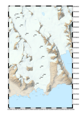
RI map

Contact
Bartłomiej Luks
luks@igf.edu.pl
Info
land platform (on ice)
Operational
Yes
Observation Facility ID
11500
Geospatial location
POINT (15.63444 77.05627)
250.00
Environment
Hansbreen surface mass balance monitoring programme started in 1988 on the initiative of the University of Silesia in Katowice. Since the beginning of XXi century programme is run under the umbrella of Polish Polar Station Hornsund owned by IG PAS. Hansbreen (HAB) is a medium-sized (56 km2) tidewater glacier located in the southern part of Wedel Jarlsberg Land, close to the Polish Polar Station in the fjord Hornsund. The glacier is ~16 km long, and elevations extend up to 550 m a.s.l. Surface mass balance monitoring started in 1988/89. Over the period of 1989-2017, the net surface mass balance has been continuously decreasing, with a mean of -0.36 m w.e. a-1. Frontal ablation, measured along the c. 1.5 km long ice cliff shows that mass loss by calving contributes substantially to the total mass loss (23-50%, i.e. additional ablation by an equivalent of c. -0.7 m w.e. a-1 on average) and varies interannually. SMB data are reported on a yearly basis to the World Glacier Monitoring Service.
Observed Variable(s)
CRYOSPHERE>GLACIERS/ICE SHEETS>GLACIER MASS BALANCE/ICE SHEET MASS BALANCE
Stake network is controlled twice a year. In Spring: April/May, in the Autumn: September/October.
Ablation and accumulation measurements are carried out at least once a year. If possible, stake readings are taken twice a year: Spring and Autumn. Bulk snow density measurements are taken in the snow pits. Surface Mass Balance data are reported on a yearly basis to the World Glacier Monitoring Service.
Additional photos