SIOS offers funded access to research infrastructure owned by our members in and around Svalbard. The infrastructure available in this call is described below.
It is recommended that applicants make contact with the access provider (contact details below) to discuss the requirements of their project before submitting their application. In addition, questions may also be directed to the SIOS Observing Network Infrastructure Officer.
When contacting the access provider, please include, as a minimum, the following information:
- Your name and affiliation.
- The number of people in your group.
- Details of your planned fieldwork (dates, location, type of environment, type of work). Please be as specific as possible.
- The needs of your project, in terms of access, logistical support, equipment, data, other support from staff at the facility.
- The level of experience and needs for safety training for the members of the group.
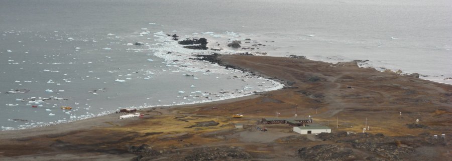
Hornsund
The Stanisław Siedlecki Polish Polar Station offers access to SIOS projects throughout the year, up to a limit of 30 person days. The station is run by the Institute of Geophysics of the Polish Academy of Sciences.
See here (pdf), the station website and the entry in European Polar Infrastructure Database for more details about the station.
Contact person: Station Manager - Włodzimierz Sielski (sielski@igf.edu.pl)
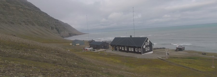
Hopen and Bear Island
One person can be accommodated at Hopen, and 2 people at Bear Island, for 1-2 weeks. Please write to Thomas Olsen (contact details below) before applying, to check available dates.
The person(s) have to arrange and pay for transport themselves (but the Norwegian Meteorological Institute can give relevant information/guidance). Travel funding of up to 15 000 NOK is available from SIOS. It is not possible to offer a separate office or a lab, but there is space for equipment of reasonable size.
The Norwegian Meteorological Institute facilitates external institutions' needs for research related equipment and support on the islands. Cost recovery for electricity, Internet connection, accommodation and man-hours for practical support is agreed for each case.
More details about Hopen: http://hopenmeteo.no/ and Bear Island: http://bjornoya.org/. See also entry in European Polar Infrastructure Database for Hopen and Bear Island.
Contact person: Thomas Olsen (thomas.olsen@met.no)
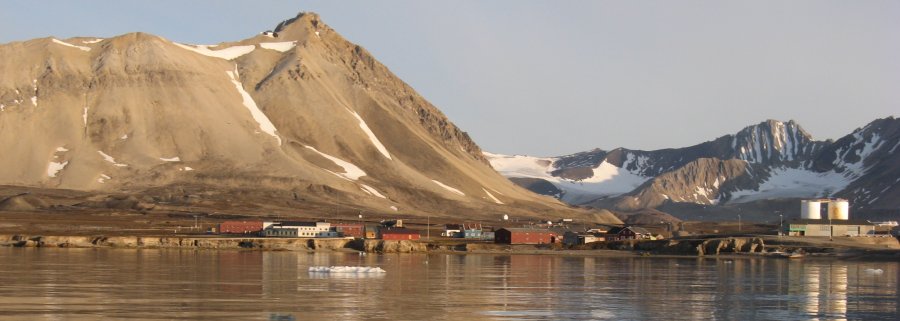
Ny-Ålesund Research Station
Ny-Ålesund is a unique station for Arctic research and monitoring of environmental change. Access to facilities in Ny-Ålesund is offered by the Alfred Wegener Institute, the National Research Council of Italy and the Norwegian Polar Institute. You can find information about the research station as a whole in the Researchers Guide to Ny-Ålesund.
Facilities offering access in Ny-Ålesund:
- AWIPEV
-
- On site access to the observatories: Access to the observatory facilities in Ny-Ålesund can be made available for joined observational programmes with the respective PIs. We therefore recommend that potential applicants contact Observatory PIs before submission of applications through Scientific Coordinator Marion Maturilli (contact details below).
- For more details about the station see the European Polar Infrastructure Database and https://www.awipev.eu/
- Contact person: Marion Maturilli (marion.maturilli@awi.de)
- Dirigible Italia
-
- Access limited to not more than 2 people per project per period
- Length of stay flexible (up to 60 person days in total)
- Reduced capacity April / early May and June / July, but access may still be possible during these times.
- Access to data from observatories (more information here)
- For more details about the station see here , https://www.isp.cnr.it/index.php/en/infrastructures/research-stations/dirigibile-italia and European Polar Infrastructure Database.
- Contact person: Mauro Mazzola (mauro.mazzola@cnr.it)
- Sverdrup (Norwegian Polar Institute)
-
- General access to Ny-Ålesund. NPI can host research groups for projects in 2025 to Sverdrup. This includes accommodation, board, and access to facilities like office space and field equipment. We can also offer boat transport services.
- For more details see information about Sverdrup on the NPI website, in the European Polar Infrastructure Database and in the Researchers Guide to Ny-Ålesund.
- The budget must include the additional costs for the required field equipment and field support. Pricelist Varekatalogen.
- Contact person: Arnt Rennan (headnpi.nya@npolar.no).
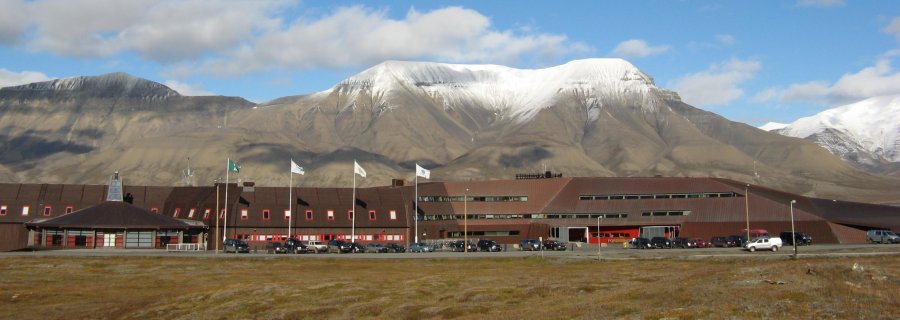
Longyearbyen - Svalbard Science Centre
The Norwegian Polar Institute offers logistical services for fieldwork across the Arctic from its office in Longyearbyen. It is possible to rent equipment, get field technician support and boat transport services (open Polarcirkel boat within Isfjorden), but there is no access offered to offices or labs. Rifles and scooters are not rented to non-NPI employees
- For more details see https://www.npolar.no/en/logistics/
- Contact person: Einar Eliassen Berntsen (einar.berntsen@npolar.no)
For more details about Svalbard Science Centre see the European Polar Infrastructure Database.
The Norwegian University of Science and Technology
NTNU offers a wide range of aerial, marine, and submarine drones that can be used for all sorts of applications. We have extensive experience with mapping, monitoring, measurements, sampling, and testing using autonomous systems. In the past, we have supported researchers in the fields of glaciology, cryosphere, biology, geology, geomorphology, geophysics, meteorology, archeology, and more. In addition, NTNU has a small satellite in space that can provide frequent hyperspectral imagery of individual sites in Svalbard.
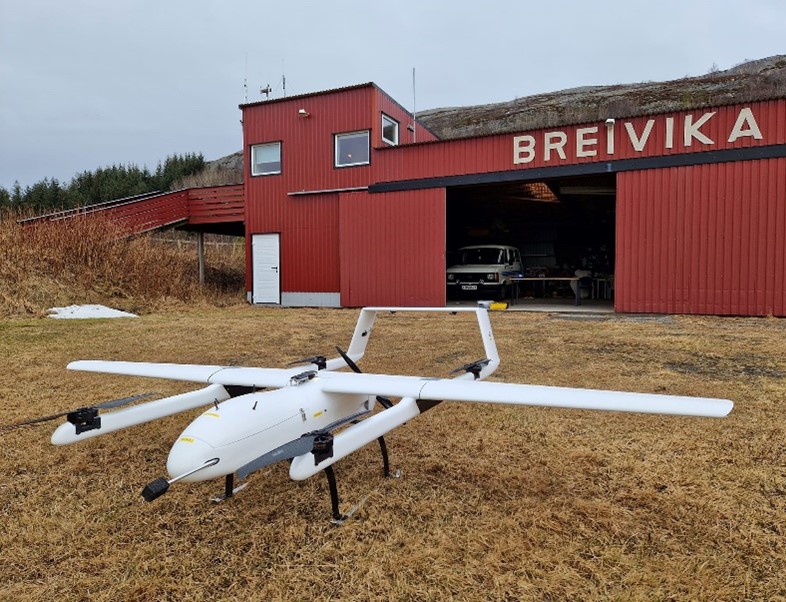
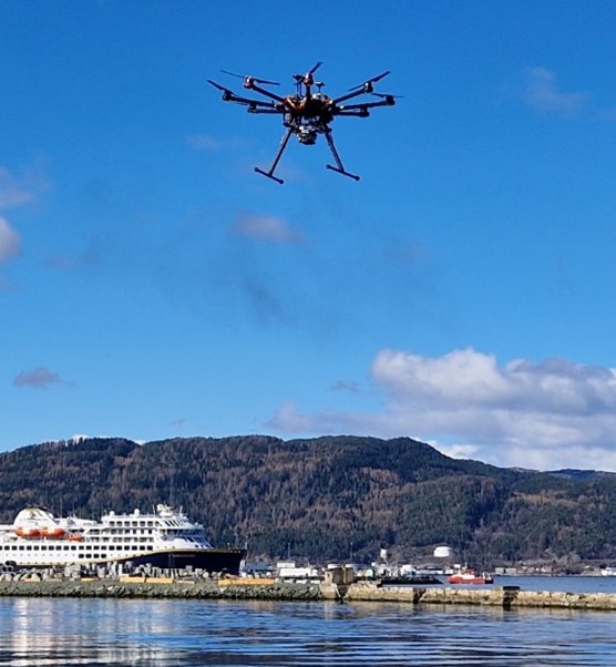
- Uncrewed Aerial Vehicle Lab
-
The Norwegian University of Science and Technology offers several drones via its UAV Lab. The offer ranges from large fixed-wing drones, to smaller rotary-wing drones, and a selection of sensor payloads. The Lab can supply different platforms and also provide a pilot to operate these. Services also include fieldwork planning and application for permits to fly complex and extended missions. In particular, this includes flights beyond visual line of sight, night-time operations, flights above 120m altitude, and more. NTNU offers the following platforms. Please contact the access provider before submitting an application in order to get a more detailed budget.
Name Type Max payload
(kg)
Max speed
(m/s)
Max flight time
(minutes)
Max range
(km)
Link Price (indication)
(NOK per day)
Mugin-2 Pro Fixed-wing VTOL 5 32 30-50 80 Link 11 600 (pilot, required) + 10 000 (drone) MR PX-31 Falk Fixed-wing 7 40 90 100 n/a 11 600 (pilot, required) + 15 000 (drone) DJI M600 Pro Rotary wing 6 18 16-35 5 Link 11 600 (pilot, optional) + 5 000 (drone) Mavic 2 Pro & Zoom Rotary wing n/a 20 15-30 5 Link 11 600 (pilot, optional) + 5 000 (drone) The Mugin-2 and the M600 can be equipped with a large range of payloads. The Lab can offer support to integrate any custom-made payloads into our systems.
Name Type Sensor resolution
(px)
Ground Sample Distance (GSD)
Link
Specim AFX10 Hyperspectral imaging, VNIR 400-1000 nm 512 or 1024 7-14 cm @ 100 m AGL Link Micasense RedEdge-MX DUAL Multispectral imaging, 10 bands 1280 x 960 8 cm @ 120m AGL Link Sony ILX-LR1 RGB (inter-changeable lens) 9504 x 6336 n/a Link FLIR Vue Pro Thermal imaging 1280 x 720 n/a Link The Lab can support a large range of scientific applications in Svalbard, for example, but not limited to:
Coastal mapping & monitoring Glacier mapping
Contact person: Richard Hann (richard.hann@ntnu.no) & Tor Arne Johansen (tor.arne.johansen@ntnu.no).
- Sea ice mapping
- Permafrost observations
- Vegetation (NDVI) mapping
- Digital outcrop mapping
- Animal surveys
- Atmospheric in-situ measurements
- Meteorological meaurements
- Applied Underwater Robotics Lab
-
The Applied Underwater Robotics Laboratory operations provide access to the use of sophisticated marine technology that gives access to information from places which are difficult to access. Our fleet includes remotely operated vehicles (ROVs), autonomous underwater vehicles (AUVs) and light AUVs (LAUVs), and unmanned surface vehicles (USVs). The Lab can offer support to activities in Svalbard and on longer cruises. Rates are depending on the project scope. Rates are depending on the platform and project. Projects need to cover the costs for freight and logistics in addition to the rental cost. Please contact the access provider before submitting an application in order to get a more detailed budget.
Name Type Specifications Price Indication
(NOK/day)
Comment Blueye X3 Mini ROV 10 kg, depth: 300m, payload: camera and light. LINK 11600 (pilot, optional) + 4000 (ROV) Minimum 5 days Blueye X3 Extra payload Gripper, additional camera and light, positioning 2000 Blueye X3 Extra payload Aqua Troll, pH, CTD, RDO (dissolved oxygen), turbidity 3000 Oceanscan LAUV Light AUV Water column AUV, 35 kg, depth 100m. LINK 11600 (pilot, required) + 12000 (AUV) Minimum 5 days Maritime Robotics Mariner USV Surface vehicle. LINK 11600 (pilot, required) + 12000 (AUV) Requires logistics for launch and recovery 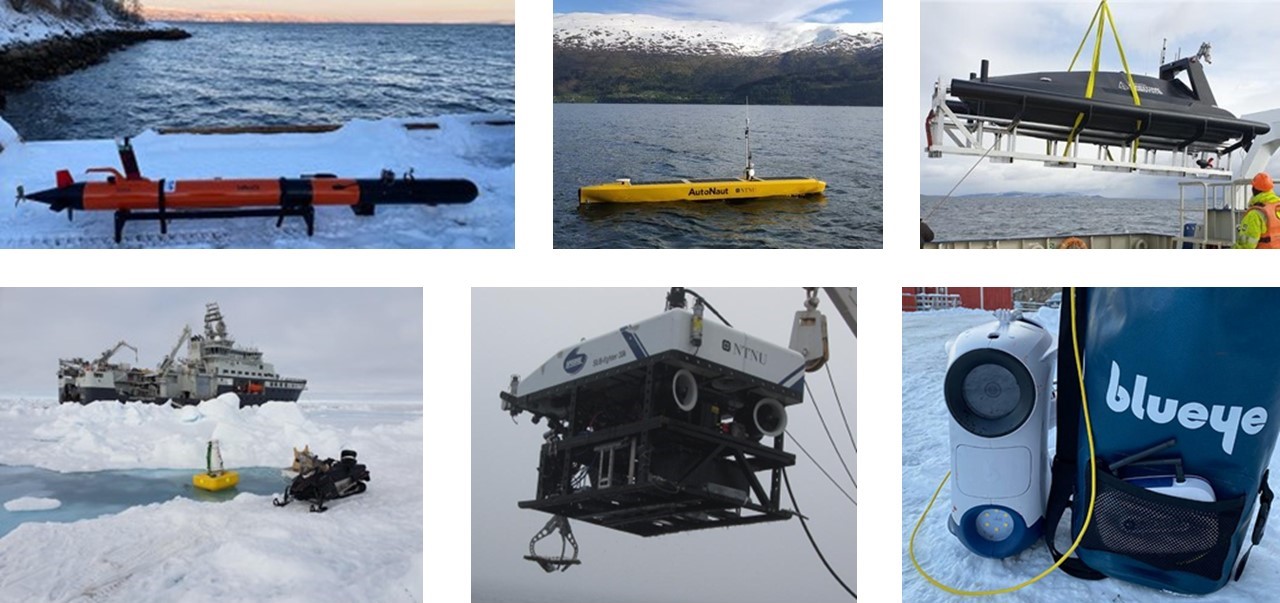
Contact person: Martin Ludvigsen (martin.ludvigsen@ntnu.no) & Antonio Vasilijevic (antonio.vasilijevic@ntnu.no). - Small Satellite Lab (Remote Access)
-
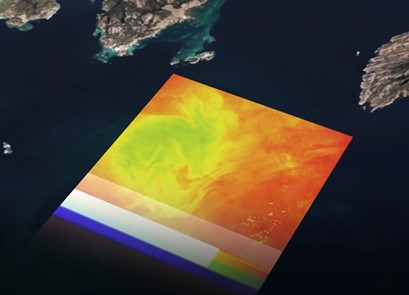
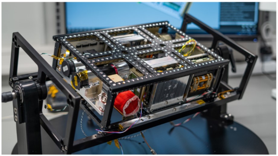
The Small Sat Lab has developed and launched the HYPSO-1 – a tiny satellite trying to make big waves in ocean research. It is a 6U CubeSat developed by the NTNU. This miniature satellite, no larger than 6 liters in volume, is equipped with a hyperspectral imager, which lets us observe the world from a new perspective. What sets it apart is its ability to capture visible light and invisible details based on color and in much greater detail than conventional cameras.
Since its launch in January 2022, HYPSO-1 has been on a mission with real-world implications. Its primary focus is on harmful algal blooms, a phenomenon that can disrupt marine ecosystems and pose health risks to humans. By capturing images of the ocean's color in high spectral detail, HYPSO-1 is instrumental in detecting and tracking these blooms early to mitigate their adverse effects.-
HYPSO-1's imager can see a range of colors invisible to the naked eye, from violet to near-infrared. Their unique spectral signatures allow scientists to differentiate between healthy and harmful algae.
-
The hyperspectral payload consists of a hyperspectral imager and an RGB camera. The HSI is a custom-built pushbroom imager with a transmissive grating, designed for the spectral range of 400 to 800 nm. The full spectral range of the instrument is about 220 to 960 nm, but close to no light is recorded below 400 nm and wavelengths above 800 nm are contaminated with second order diffraction effects. The theoretical spectral bandpass is 3.33 nm, and all measured values are below 5 nm.
-
HYPSO-1 can capture images with a resolution close to 150 meters under good conditions. This level of detail allows researchers to narrow down algal blooms' location and extent.
-
The design HYPSO-1 allows for quick responses. Unlike larger satellites aiming at global coverage, it can focus on the same area more frequently, providing scientists with closer-to-real-time data on how algal blooms evolve, up to several times per day.
The NTNU SmallSat Lab can offer hyperspectral image coverage of user-selected sites in Svalbard with high temporal resolution, for more information, please reach out to the contact persons. The rates for establishing a monitoring site are about 10,000 NOK per site for a full year. Please contact the access provider before submitting an application in order to get a more detailed budget.
Contact person: Richard Hann (richard.hann@ntnu.no) & Tor Arne Johansen (tor.arne.johansen@ntnu.no).
If you want to learn more about the HYPSO-1 satellite, please see the following documentation.- Bakken S, Henriksen MB, Birkeland R, Langer DD, Oudijk AE, Berg S, Pursley Y, Garrett JL, Gran-Jansen F, Honoré-Livermore E, et al. HYPSO-1 CubeSat: First Images and In-Orbit Characterization. Remote Sensing. 2023; 15(3):755. https://doi.org/10.3390/rs15030755
- M. E. Grøtte et al., "Ocean Color Hyperspectral Remote Sensing With High Resolution and Low Latency—The HYPSO-1 CubeSat Mission," in IEEE Transactions on Geoscience and Remote Sensing, vol. 60, pp. 1-19, 2022, Art no. 1000619. https://doi.org/10.1109/TGRS.2021.3080175.
-
Ocean Glider
The University of Bergen offers access to an ocean glider (1000-m rated) for limited missions that can be supported within the access call budget. The ocean glider is coordinated and operated by the Norwegian National Facility for Ocean Gliders (NorGliders https://norgliders.gfi.uib.no) at the Geophysical Institute, University of Bergen. The operation area of the glider is the ocean area west of Spitsbergen and Isfjorden, and must be in open waters at safe distance from sea ice.
The user is expected to facilitate deployment and recovery opportunities for the mission and cover the costs for freight and logistics associated with the deployment and recovery (these are not covered by Access). The weekly rate for the glider in 2025 is 30 000 NOK. A start-up cost of 4 weeks must be included for preparations, tests, and the occupation of the glider for freight and similar. 1-week access cost is thus (5x30 000) 150 000 NOK, and 3 weeks cost is (7x30 000) 210 000. The maximum mission duration that can be sought is 11 weeks (450 000 NOK). The user can apply for such a relatively long mission by supplementing the SIOS Access funding by other means. In the case of a failed mission with no or reduced data return, a minimum of 1 week (150 000 NOK) cost must be covered.
Contact person: Ilker Fer (ilker.fer@uib.no)
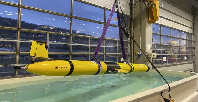
Photo: Ilker Fer
