by Janne E. Søreide (UNIS); Daniela Walch (UNIS, NIVA, UQAR), Martin Ludvigsen (NTNU),Tore Mo-Bjørkelund (NTNU), Simon Bèlanger (UQAR), Rakesh Singh (UQAR) and Amanda Poste (NIVA)
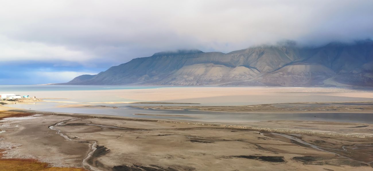
The Arctic is characterised by an extensive coastline that constitutes 1/3 of the global coastline. These nearshore waters are among the most productive regions in the Arctic, representing important breeding and foraging grounds for many fish, birds and marine mammals. Global warming with increased river runoff combined with coastal erosion, due to more stormy weather and less landfast sea ice, leads to massive sediment plumes. This coastal darkening may have negative impacts on the primary productivity in nearshore waters and there is a need to monitor the extent and seasonal dynamics of these turbid plumes. So far available research on Arctic nearshore or coastal water quality has been based on in-situ measurements. However, the plumes vary temporarily and spatially and are challenging to study by traditional in-situ tools due to their dynamic nature.The temporal and spatial extrapolations of in-situ point measurements is therefore not sufficient to fully understand the extent and magnitude of these plumes over seasonal and shorter time scales.
To improve our understanding of these plumes applications of Earth Observation (EO), airborne and satellite-based remote sensing (RS) are very promising tools. These can be used to assess the magnitude and variability of optically active constituents (OACs), such as Suspended Particle Matter (SPM), present in the water body. Ocean Colour Remote Sensing (OCRS) can be used to estimate the concentration of the OACSs with a high-degree of accuracy, but most algorithms are developed for oceanic and not highly sediment-loaded coastal conditions. New coastal adapted algorithms are therefore needed before OCRS can be efficiently used in regular coastal monitoring.
The overall aim of this project was to improve the accuracy of Ocean Colour Remote Sensing to determine the dynamic nature and extent of river plumes in the high-Arctic.
To accomplish this we needed to develop coast-specific algorithms and this was done by extensive calibration/validation work in Adventfjorden, Svalbard in summers 2019, 2020 and 2021 by in-situ surface water sampling simultaneously with satellite passing (Sentinel II) and / or airborne remote sensing campaigns (Dornier 228 LN-LYR, SIOS-NORCE).The pandemic challenged our fieldwork, but we were able to complete the project due to the valuable help from master students present at the University Centre in Svalbard (UNIS) and by extending the project with one more year. The severe travel restrictions largely hindered the international partners to be physically present in Svalbard and also led to one cancelled UNIS master / PhD course delaying the Autonomous Underwater Vehicle (AUV) campaign to 2021 when the course was run again. During this campaign, mapping of the surface waters in Adventfjorden was done simultaneously in sea using the AUV and from air using the Dornier. Data from 2021 are still under analysis. In-situ water sampling was conducted monthly from May to September each year and we aimed for non-cloudy sampling days to ensure good satellite images. Further we were allocated Dornier flight hours by SIOS/NORCE in 2020 with flight dates 11th June and 21st July (6th September we sampled Agardbukta, East Spitsbergen, too in 2020) and in 2021 Adventfjorden cal/val grid (see below) was sampled again 25th and 28th August.
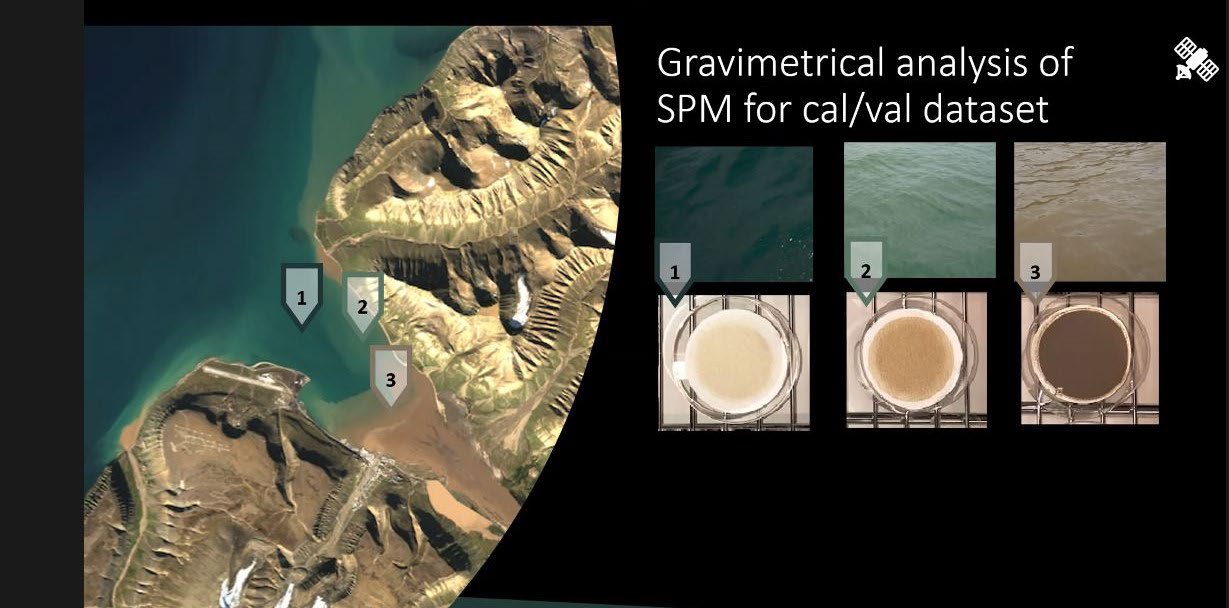
Master student Daniela Walch (supervised by A. Poste, NIVA; JE Søreide, UNIS and H. Lantiut, Potsdam University) in close cooperation with the remote sensing experts Simon Bélanger and Rakesh Singh,Quebec University in Rimouski (UQAR) developed a regionally tuned semi-analytical ocean colour algorithm (non-linear least squared regression analysis) to estimate suspended particulate matter (SPM) in the fjord by validating satellite images with the in-situ water samples (see below).
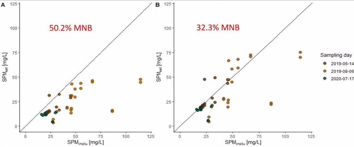
The mean net bias (MNB) of remotely sensed SPM estimates was reduced by ~20% for the regional calibration algorithm (AdvFCal) (see figure below). The error was, however, still large (30% MNB) but significantly improved and within an acceptable range for these highly dynamic coastal areas, where seasonal variability in different organic and inorganic constituents impact the ocean colour and subsequently the algorithm’s capability of accuracy.
This work has resulted in one published and two submitted manuscripts so far. Next step is to explore the potential of the hyperspectral data collected during the airborn remote sensing campaigns to improve Chlorophyll a estimates (productivity) in coastal waters in Svalbard. For more details about sample collections and results see attached Appendix (10 pp).
- Klein KP, Lantuit H, Heim B, DoxaranD, Juhls B, Nitze I, Walch D. Poste A, Søreide JE(2021). The Arctic Nearshore Turbidity Algorithm (ANTA)-A multisensor turbidity algorithm for Arctic nearshore environments. Science of Remote Sensing4, 100036.
- Singh RK, Castro de la Guardia L, Mundy CJ, Søreide JE, Vader A , Dunton K, Iken K, Sejr MK, Bélanger S (submitted) Satellite-derived photosynthetically active radiation at the coastal Arctic seafloor. Elsvier.
- Walch DMR, Singh R,Søreide JE, Lantuit H, Poste A (submitted) Spatio-temporal variability of suspended particulate matter in ahigh-Arctic estuary (Adventfjorden, Svalbard) using Sentinel-2 timeseries. Remote Sensing.


The left panel shows the water station-grid in Adventfjorden with the corresponding flight route (right panel) for the Dornier - the airborne remote sensing platform operated by NORCE.